Goa is abuzz with excitement as vintage bike and car owners, users, collectors and fans are decking […]
Old is Gold
October 4, 2016
By Solano Da Silva and Tahir Noronha
Protests are rising against any further industrial development of Goa through confusing and half-baked twisting of the zoning plan by Industries Minister Vishwajit Rane…
The Government of Goa has introduced a slew of land use policies. These include amendments to the GTCP Act, such as 16B and 17.2; a revamped IPB Act; a host of new PDAs with accompanying ODPs; and most recently, a standalone zoning plan for an entire taluka (personified in The Pernem Zoning Plan). All of these new ‘land’ policies either explicitly or implicitly claim that the existing regional plan, the RP-2021, is defective or insufficient. Specifically, in May, the TCP Minister claimed that 6 crore sq. m. was taken out of settlement zone by RP-2021. This claim requires scrutiny. When comparing the RP-2021 with the RP-2001, one finds that the RP-2021 actually expanded settlement zones but also clearly demarcated settlements from agricultural and natural cover. Corrections to the RP-2021 by systematically surveying natural cover and agricultural zones and rationalising ODPs with the RP-2021 were required. However, these are not the corrections that the TCP Minister is pursuing. Instead, he, like his predecessors, has unleashed a host of new land policies that are essentially state-sanctioned tools to encroach into the state’s shrinking agricultural land and natural cover. Further, he has tried to execute them in a manner that lacks transparency and public participation. Finally, on revisiting the controversial history of land-use planning in Goa, one finds that RP-2011, a plan that the people of Goa had vehemently opposed, is the only case where land use changes similar to the minister’s figure of 6crore arises.
Part- I
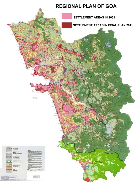
RP-2021 did not reduce settlement zones but added
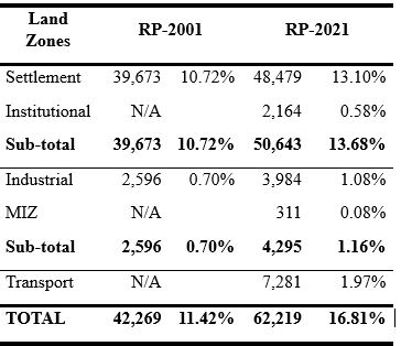
The RP-2001, notified in 1986, designated a total of 41,669 ha for construction purposes. In other words, 11% of the state’s land surface was set aside for various development purposes. As shown in Table no. 1, This comprised 39,673 ha designated for settlement and 2,596 for industrial purposes. Moving to RP-2021, notified in 2011, if one sums up the areas demarcated for settlement, institutional, industrial, MIZs, and transport purposes, one arrives at a total developable area of 62,219 ha. Thus, approx. 17% of Goa’s land surface was set aside for various construction purposes. Since the RP-2021 was more detailed than RP-2001, settlement zones were bifurcated into settlement zones and institutional zones, which together add up to 50,643 ha (13.68%), as shown in Table no. 1. When comparing RP-2021 with RP-2001, one finds that RP-2021 actually added 10,970 ha to settlement zoning, contrary to the TCP Minister’s claims. Further, the RP-2021 also added another 1,699 ha for industries. This is not to mention that yet another 9,252 ha (or 2.52 % of Goa’s land) is under mining activities.
There are a number of reasons that were given for the increase in settlement zones in RP-2021. Amongst them was that the zoning needed to be updated with the hundreds of individual zoning changes that Goan politicians had made to RP-2001 between 1988-2005. The gazette zoning changes were the reason for the TCP earning the tag of a ‘lucrative’ portfolio. This unscientific and corrupt practice was brought to an end in 2005 when Goa came under Governor’s rule. 16B, 17.2 and the power to change land zoning through the IPB Act are recent avatars of the gazette zone change practice.
One has to realise that the RP-2021 detailed settlement zones clearly and, to avoid ambiguity, marked the settlement areas with survey nos. It simultaneously also marked areas for Eco-1 And Eco-2 to protect agricultural lands and ecologically valuable areas.
There were lapses in planning in RP-2021. Substantively, some verification was hurriedly done. RP-2021 missed the opportunity to survey natural cover zones in tandem with the forest department, survey agriculture lands, and develop an agriculture policy; and critically, include ‘urbanised’ areas which had ODPs into the regional plan. Procedurally, two approaches also led to less trust in the planning process, namely: a relatively opaque process followed by the State Level Committee to process 8,500 suggestions and objections, The reluctance of the state to send the final plan back to village panchayats for their ratification.
Despite these shortcomings in the plan, we could not find a “large-scale zone conversion to the tune of 6 crore square meters.” The minister presented a report on the floor of the assembly, which makes circumstantial allegations but does not reasonably find any widespread fraud. So how did the TCP Minister come up with a figure of 6 crore sq m.?
Part – II
Instruments to zone away Agricultural and Natural Cover
While pointing out flaws with RP-2021, the TCP Minister follows a trajectory which is very similar to that of the previous TCP Minister, Vijay Sardessai. Recall that Sardessai also pointed out flaws with RP-2021, but instead of correcting the plan – a promise of the BJP – he notified the plan. Importantly, he amended the TCP Act with 16B, enabling him to make spot zoning changes to RP-2021. Sardessai also created new PDAs and ODPs, which the BJP allocated to different politicians. Now, Vishwajeet Rane has created his own version of the very same tools: introducing section 17(2) to the TCP Act, amending the Goa Building Construction Regulations to circumvent zoning provisions, and introducing section 17D to enable the department to prepare new zoning plans such as the Pernem Zoning Plan.
Most importantly, a scrutiny of the new land policies – 16B, 17.2, the ODPs and the Zoning Plans – reveals that they are essentially tools that the TCP ministry has used to arbitrarily re-zone agricultural and natural cover zones for settlement and commercial purposes. The manner in which they have been used to convert land lacks transparency and sound scientific basis.
An analysis of zoning changes processed under 16B for just one year (January 2019 to December 2020) indicates that over 7 km2 were sought to be converted in just one year. An overwhelming majority of the changes proposed converting agricultural land. 90% of all 16B changes seek to be diverted for real estate development purposes towards settlement or commercial zoning.
The current TCP Minster’s 17(2) amendment to the GTCP Act enables private property owners to request changes in zoning. A simple scrutiny of the first 20 cases approved under section 17(2) indicates that 54% of agricultural land and 46% of Natural Cover is sought to be converted. 17.2 goes even further by dispensing with the practice of inviting objections from the public prior to finalisation.
There have also been a series of drafts, and final ODPs floated in the recent past that proposed development in eco-sensitive zones without any fact-base or study. Most of these have been challenged, and cases pending in the High Court. ODPs in Bardez and Mormugao were withdrawn by the TCP department after a government committee highlighted the high-handed and arbitrary rezonings in it. This report justified the negative sentiment towards these poorly planned areas. The ODPs contradict their professed purpose of detailing our critical areas within a broad-brush Regional Plan. In fact, other Indian states use detailed plans, such as ODPs and zoning plans, as subsets of the Regional Plan, detailing and changing densities and defining settlement zones within the fence into residential, commercial, and public uses. There is no provision for detailed plans to exceed settlement fences determined in the Regional Plan.
A similar analysis of the recent Pernem Zoning Plan by activists and journalists indicates that 1.4 crore sq m. (i.e. 1,400 ha) has been carved out from green cover for construction purposes. In other words, 21% of the green cover that was protected by RP-2021 in Pernem has been conveyed. Further, the Village Panchayats in the taluka were neither consulted when formulating the zoning plan nor was the report accompanying the zoning plan made public. A scrutiny of a number of permissions issued through the IPB Act reveals the same trend that this policy has essentially armed the government with enormous discretionary power, which has been (mis)used to zone away agricultural and ecological areas for select parties.
Part – III
TCP Minister’s mysterious 6 crore sq.m. and the infamous RP-2011
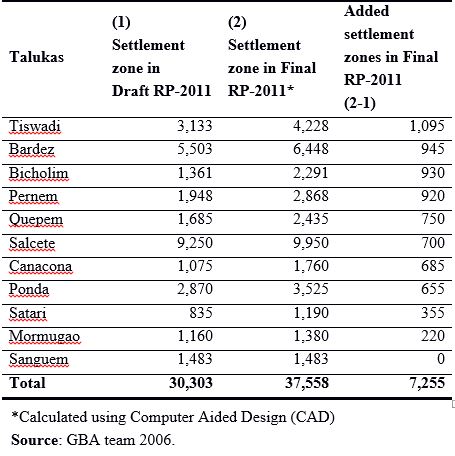
This analysis has already demonstrated that the RP-2021 actually added areas under the settlement zone. Our analysis shows that the TCP’s new land policies are not used to correct or improve the RP-2021 but to unleash a rapid and wanton conversion of agricultural lands and natural cover. A perusal of Goa’s controversial planning history reveals that the closest reference to the mysterious 6 crore sq. m (or 6,000 ha) is the extent of the land that was sought to be converted by the infamous RP-2011 that was scrapped following a public outcry by the people of Goa. Many would recall the gross differences in settlement areas when comparing draft and final versions of the RP-2011. These “back-door rezonings” raised initial suspicions about the plan. Since there was no accompanying table with the final RP-2011, which recalculated the different zones document, it was difficult to obtain the areas of the respective zones that had been diverted to settlement. Instead, activists across the state resorted to Computer Aided Design software (CAD) to compare the draft and final RP-2011 and calculated that 7,255 ha (or 7 core sq.m.) of land across the state had been rezoned as settlement.
 LETTER TO THE EDITOR FOR THE ISSUE DATED JUNE 20, 2026
 SUFFOCATING GREY SKYLINE OF GOA! By Raaisa Lemos Vaz
 EXPENSIVE SHOCK!
 WELCOME TO `VERRE’!
 INDIA’S GULF RELIEF MOMENT!By Arvind Pinto
 GOA AT A CROSROADS: Governance, Deficits & Disconnection!By Dr Olav & Deborah Albuquerque
 REMEMBERING SAVITA!By Prema Vishwanathan
 ONLY 9% STUDENTS IN KONKANI MEDIUM Nobody wants Hindi in amche Goye!
 TAKE CHARGE OF YOUR BRAIN Unlocking Neuroplasticity for a Sharper Future! By Dr Amit Dias, MD
 WEEKEND UPDATESLETTER TO THE EDITOR FOR THE ISSUE DATED JUNE 13, 2026
 ALICE & DEAN D’CRUZ: RAKHANDAR OF SALIGAO!
 WHY ARE THE FISH DYING? By Raaisa Lemos Vaz
 THE RISE OF THE JANATA COCKROACH PARTY! By Arvind Pinto
 BEYOND THE NOBEL!By Pinakpani Bharadwaj
Goa is abuzz with excitement as vintage bike and car owners, users, collectors and fans are decking […]