Goa is abuzz with excitement as vintage bike and car owners, users, collectors and fans are decking […]
Old is Gold
October 4, 2016
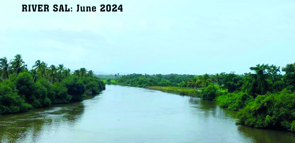
The Sal river is under stress like the other rivers in Goa. The Sal rises in the Verna hills, flows through the industrial estate before passing through Khareband in Margao, and finally into the sea at Mobor beach in south Goa. The Sal river is choking with pollution at every stage in its long troubled journey…
THE river Sal, once a pristine and economically vibrant waterway in Salcete taluka of South Goa, is today, under visible stress. As Goa’s 3rd largest river, it is unique. It originates and drains within the same taluka, rising in the hills of Verna and flowing 35 km southwards to meet the Arabian sea at Mobor. Historically abundant, the river has steadily declined due to rapid urbanisation, floodplain encroachments, poor waste management and the loss of ecological function. In the year 2018, the Central Pollution Control Board classified the Sal as Priority III (moderately polluted). Alarmingly, by 2024, its status was upgraded to Priority II (severely polluted), indicating worsening conditions despite multiple interventions over the years.
The System That Sustains Us
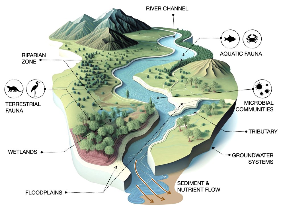
RIVERS are dynamic freshwater systems that flow from higher to lower ground, shaping landscapes and sustaining life along their course. Ecologically, they are vital. Floodplains moderate floods, wetlands filter pollutants and riparian vegetation stabilizes banks, regulates microclimates and contributes to carbon sequestration. Together, these functions make rivers critical corridors for biodiversity, nutrient cycling and groundwater recharge.
Beyond their ecological role, rivers are central to human civilization. They support domestic, agricultural and industrial needs while underpinning livelihoods through fisheries and resource supply. They guide the location of cities, enable trade and cultural exchange and continue to influence social and economic systems. Access to reliable river systems ensures food security, public health and economic stability, making their preservation fundamental to long term human resilience.
In Goa, rivers are integral to both ecology and economy, providing water for consumption and irrigation, enabling transport and supporting local resource systems. Characterized by unique rain-fed and tidal regime, they experience tidal influences up to 40 km inland. This creates a seasonal shift, from freshwater conditions during the monsoons to brackish phases post-monsoon. Hence, affecting not only the rivers system but also the adjacent wells and communities.
Yet, increasing anthropogenic pressures like rapid urbanization, untreated sewage disposal, solid waste mismanagement, industrial effluents and unsustainable agricultural practices have disrupted these natural processes. Altered flow regimes and declining water quality are degrading habitats, reducing biodiversity and weakening the river’s inherent capacity to regenerate, posing a growing challenge to both ecological stability and human well-being.
River Rewritten by Development
RIVER Sal’s transformation from a productive lifeline to a stressed system is closely tied to rapid and often unplanned urbanization in Salcete, where urban population growth has surged by over 72% as per Census 2011, accompanied by a 40% rise in rural areas. This expansion has left a visible ecological footprint. Dealing Normalised Difference Vegetation Index (NDVI) values indicate a steady loss of riparian vegetation which is critical buffer that stabilizes banks, filters runoff and supports biodiversity. Simultaneously, encroachments and infrastructure within floodplains have disrupted the river’s natural flow regime, severing its lateral connectivity with adjoining landscapes. Such disconnection reduces the river’s capacity to absorb floods, recharge ground water and maintain ecological balance.
Cumulative Pressures and Structural Gaps
Urbanisation:
River Sal reveals a landscape increasingly shaped by human intervention, where natural processes are being steadily constrained. The river corridor is characterized by a mixed-use setting of agricultural fields, interspersed with expanding residential and commercial settlements, often extending into the floodplains. Engineering responses, such as retaining walls and concrete embankments along outer bends and near bridges, indicate attempts at bank stabilization and settlement protection. However, these interventions have altered flow dynamics and significantly reduced the river’s lateral connectivity with its floodplains, limiting its capacity to absorb floods and recharge groundwater.
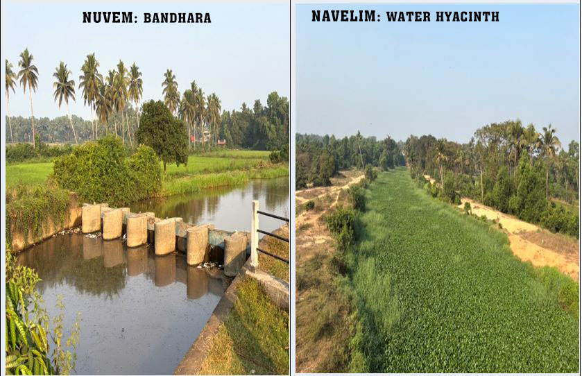
Agriculture: Agriculture dependence on the river is evident through multiple bandharas that regulate and retain water for irrigation, maintaining high water levels even during dry months. While this supports local livelihoods, it also contributes to reduced downstream flow, sediment accumulation and stagnation.
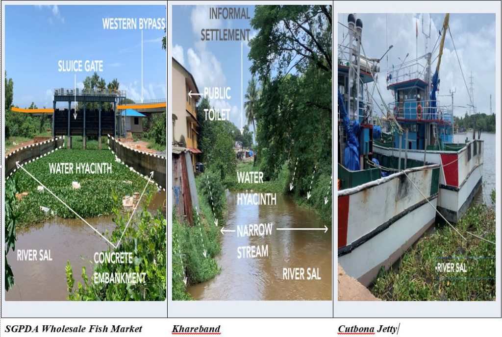
Encroachments: Encroachments are widespread with formal developments and reinforced embankments on one bank juxtaposed with informal settlements on the other near Khareband bridge, collectively constricting the river channel. These critical stretches show severe pollution, marked by high fecal coliform levels, untreated sewage discharge and dense water hyacinth infestation. This invasive species, thriving in nutrient-rich, low-flow conditions, blocks sunlight, reduces dissolved oxygen and accelerates eutrophication, further degrading aquatic life. Large scale interventions, such as construction of the Western Bypass Highway across the floodplains at Benaulim, have further altered hydrological patterns in this area, restricting natural water movement and increasing flood vulnerability in adjacent areas. Compounding these physical disruptions are water quality concerns. These are not isolated issues but interconnected pressures that collectively degrade the river’s health.
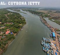
Economic Nodes: Economic nodes like the SGPDA Wholesale Fish Market and Cutbona Jetty highlight the river’s socio-economic importance but also exposes systemic gaps. Poor Solid Waste Management, untreated effluent runoff and inadequate sanitation, particularly among migrant worker communities, pose risks to both river health and public health, as seen in recent disease outbreaks like cholera at Cutbona Jetty. Even treated discharges from sewage treatment plants located within the floodplains of Navelim raise concerns about cumulative impacts.
Collectively, these observations point to a river system under stress. It is fragmented, engineered and increasingly disconnected from its ecological foundations, demanding urgent and integrated intervention. It calls for a coordinated action across administrative agencies, integration of planning frameworks and active community participation. Rejuvenation, therefore, is not merely a technical exercise but a systemic shift that recognizes the river’s ecological role and redefines our relationship with it.
Rejuvenation or Rhetoric
INDIA has developed a robust legal and policy framework for river conservation, reflecting strong institutional intent. The Water (Prevention and Control of Pollution) Act, 1974 laid the foundation by establishing the Central Pollution Control Board to monitor and regulate water quality. This was reinforced by the Environmental (Protection) Act, 1986, which empowered the government with broader authority to safeguard natural resources. Complementing these are evolving policy instruments such as National Water Policy (1987, revised in 2002 and 2012), which emphasizes integrated water resource management, prioritization of drinking water and community participation. More recently, planning-oriented guidelines like River-Sensitive Master Planning Guidelines aim to embed ecological thinking into urban development.
Institutional support has expanded through organizations like the National Institute of Urban Affairs and the National Mission for Clean Ganga, which have developed frameworks for example the Urban River Management Plan (URMP) and River Centric Urban Planning (RCUP) amongst others. International models of frameworks from the EU’s Water Framework Directive to River Health Indices in Australia, China and South Africa further inform these approaches. Yet, despite this extensive ecosystem of acts, policies and frameworks, implementation remains inconsistent.
India’s river pollution demonstrates strong policy intent, yet limited on on-ground outcomes. In 2018, the Central Pollution Control Board identified 351 polluted river stretches across the country, classifying them based on Biochemical Oxygen Demand (BOD). In response, the National Green Tribunal directed states to establish River Rejuvenation Committees and implement time-bound action plans to restore rivers to bathing standards.
In Goa, 11 polluted stretches were identified, including a 22 km segment of river Sal (Khareband to Mobor), initially classified as Priority III (moderately polluted). Despite an action plan prepared in 2019, the river’s condition has worsened, with status elevated to Priority II (severely polluted) in 2024, indicating a significant implementation gap. This decline reflects fragmented governance and the complexity of managing multiple stressors, including urbanization, untreated sewage disposal, agricultural run-off and floodplain encroachments. Additionally, ecological restoration processes are inherently slow and demand sustained commitment.
The challenge, therefore, lies not in the absence of frameworks, but in ensuring coordinated, long-term execution that translates policy into measurable outcomes.
Rebuilding the River System
Encroachments: Rejuvenating the river Sal requires a coordinated, multi-scalar approach that addresses governance, ecology and community engagement simultaneously. Immediate priority must be given to regulate encroachments. Informal settlements within floodplains need phased relocation with adequate rehabilitation, while formal developments should face strict penalties, including higher taxation and enforcement compliance.
Land Use: Floodplains must be legally protected as ecological assets, not treated as vacant land. Their delineation, indicating high tide and hazard lines, should be mandatorily integrated into all statutory plans, supported by enforceable, river-centric zoning regulations. A decentralized, context driven River Regulation Zone Framework can guide this process under broader national oversight.
Wastewater Management: Equally critical is wastewater management. Universal connection to sewerage systems in urban areas must be enforced, alongside interceptor drains to prevent untreated discharge into the river. In un-sewered areas, regulated septic systems, soak pits and periodic de-sludging should be mandatory supported by Fecal Sludge Treatment Plants. Tools such as Shit Flow Diagrams can help identify leakages and improve system efficiency.
Integrated Water Management: Hydrological and ecological restoration must focus on restoring environmental flows and rebuilding natural buffers. Measures such as constructed wetlands, rainwater harvesting in upstream agricultural lands and regulation of water retention structures can enhance groundwater recharge and sustain dry-season flows. A continuous vegetation buffer of a minimum 15 meters along riverbanks and 50 meter wide mangroves, should be enforced to stabilize soil, improve water quality and restore biodiversity.
Geo-spatial Mapping: Translating dispersed data into clear, visual formats through geo-spatial mapping is a powerful tool to reveal spatial patterns and ecological relationships. Grounded in landscape architect Ian McHarg’s theory of “creative fitting,” such mapping can guide interventions towards achieving better ecological fit between the river and its surrounding landscape. This must be paired with a shift from viewing rivers as economic assets to recognize them as ecological systems requiring stewardship.
An integrated governance approach of linking agencies, local bodies and communities is essential to move beyond fragmented efforts. Ultimately, combining geo-spatial insights with collective responsibility can restore ecological balance, making space for the river, both physically and institutionally.
Community Participation: Finally, long-term success depends on community stewardship. Strengthening local institutions, enabling participatory monitoring and incentivizing improved river health can foster shared responsibility. Rejuvenation, therefore, must move beyond isolated interventions, towards an integrated, accountable and locally grounded framework.
Is It Time to Rethink the Sal?
INSTITUTIONAL mechanisms such as River Rejuvenation Committees mark progress, but their real strength lies in meaningful community engagement. In Goa, traditional systems like the communidade offer a foundation of more grounded, context-specific stewardship. With its unique trajectory of flowing entirely within a single taluka, from hills to the estuary, the river Sal presents a compelling opportunity as a pilot for integrated, river-centric interventions. When combined with geo-spatial mapping, such approaches can bring clarity, accountability and direction to restoration efforts.
Yet, this also raises a more uncomfortable question: Has our conventional approach failed to the point where we must begin thinking differently about rivers altogether? If rivers are truly shared commons, can their future be secured without reimagining how we value them?
Emerging global ideas offer a shift in perspective. The concept of “Rights of Rivers” challenges us to recognize rivers as living entities with fundamental rights: to flow, remain unpolluted and regenerate. While “Room for the River” demonstrated the benefits of giving rivers space to function as natural systems rather than constraining them.
Do these ideas signal a necessary shift, or are they responses to crisis we have allowed to deepen for too long? In the case of river Sal, they invite a critical reconsideration — is it time to move beyond managing damage towards redefining our relationship with the river itself? What happens next will not only determine the fate of river Sal, but also reflect how we choose to live with the natural system that sustains us.
(Ar Harshada Thakkar has done BArch, Sir JJ College of Architecture, Mumbai and MArch, Goa College of Architecture, Panaji. This article is courtesy her thesis: “Mapping Anthropogenic polluters as a Strategic Tool to assess River Health: Case of River Sal and Navelim Village, Salcete, Goa”
 LETTER TO THE EDITOR FOR ISSUE DATED JULY 18, 2026
 THE VOICE OF PLANET EARTH… DIVING INTO ‘PRIMORDIAL’ By By Raaisa Lemos Vaz
 RANADHIR MUKHOPADHYAY— A MARINE GEOLOGIST WITH A PEN & A CAUSE! By Praveena Sharma
 THE MANY WAYS OF BEING HUMAN!
 THE RISE OF BANK FRAUDS – CUSTOMERS BEWARE!By Arvind Pinto
 PUT YOUR BEST FOOT FORWARD! WHY FOOT CARE DESERVES MORE ATTENTION!By Dr Amit Dias, MD
 MORE MBBS SEATS MEANS LESS JOBS FOR DOCTORS AT LESS PAY!
 POLITICAL NEXUS IGNITES FRESH PUBLIC OUTRAGE!By Dr Olav Albuquerque
 WEEKEND UPDATESLETTER TO THE EDITOR FOR ISSUE DATED JULY 11, 2026
 CONGRESS REBELS PACIFIED!
 GOA’S DAMS FACE SLOW MONSOONS!By Raaisa Lemos Vaz
 ALZHEIMER’S EMERGING AS A GROWING CONCERN IN AGEING GOA…By Dr Parul Dubey
 CAN HOSPITALS HOLD PATIENTS “HOSTAGE” OVER UNPAID BILLS?By Keral Mehta, Yati Sharma
 `THE LITTLE PRINCE’ IN MANGLISH…
Goa is abuzz with excitement as vintage bike and car owners, users, collectors and fans are decking […]