Goa is abuzz with excitement as vintage bike and car owners, users, collectors and fans are decking […]
Old is Gold
October 4, 2016
Nepal’s terrifying disaster last week was neither an ordinary flood nor a conventional glacial lake outburst. It was a chain reaction in which ice, rock, water, gravity and human greed joined forces.
By the morning of 26 August 2026, something enormous had happened high above Nepal.
The first clue was a violent tremor. Seismographs registered a signal equivalent to a magnitude 5.2 earthquake. For a moment, it looked as though the Himalaya had simply done what it has done many times before.
But there had been no earthquake. Only a mountain had moved.
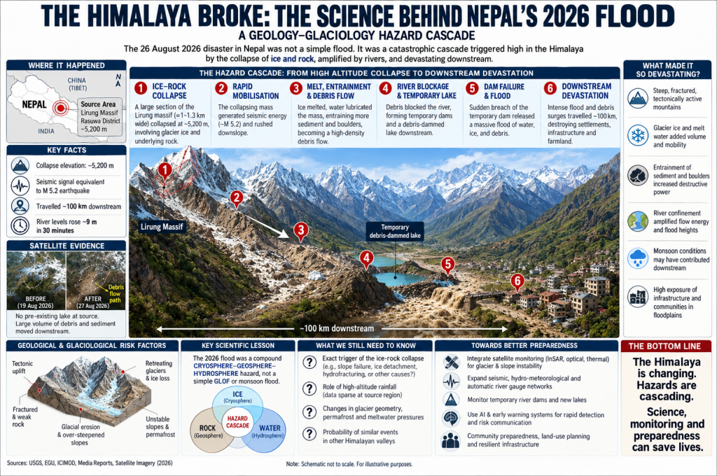
At roughly 5,200 metres in the Langtang region, a gigantic mass of ice and rock appears to have broken loose. It plunged down the mountainside with such force that the falling material generated its own seismic signal. Then it entered the river system below.
That was when a geological event became a human catastrophe.
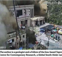
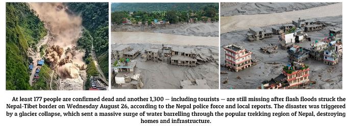
The torrent raced down the Lende Khola and Trishuli system, travelling nearly 100 kilometres. It was not water alone. Ice, mud, boulders, broken rock and sediment were swept into the flow, turning the river into a gigantic conveyor belt of destruction.
Bridges vanished. Roads were torn apart. Buildings were buried or swept away.
Hydropower projects were damaged. The vital Nepal-China corridor was hit.
A Himalaya Built to Break:
To understand what happened, forget for a moment the familiar image of the Himalaya as a magnificent wall of snow. Geologically, it is a restless young mountain system.
The Indian and Eurasian tectonic plates continue to collide, pushing the Himalaya upward. Around Langtang, the mountains are made largely of intensely deformed and fractured gneisses, quartzites and marbles. Rivers have carved deep valleys into this rising terrain, while glaciers have spent thousands of years cutting and steepening the slopes.
It is a landscape of enormous beauty—and enormous instability. The ingredients are already there: steep slopes, fractured rock, glaciers, deep gorges and powerful rivers. All that is sometimes needed is a trigger.
The first reports naturally suggested a glacial lake outburst flood, or GLOF. The Himalaya is notorious for such events. A lake forms behind a natural dam of ice or moraine; the dam fails; a wall of water races downstream.
But this time the story appears to have been different. Satellite evidence reportedly found no pre-existing lake at the collapse site.
Instead, a mass of glacier ice and rock appears to have failed almost simultaneously—or one may have triggered the other. Scientists are still considering several possibilities: a glacier collapse carrying rock, a rock avalanche incorporating glacier ice, or a compound ice-rock slope failure.
That uncertainty should not be brushed aside. It is precisely what makes the event scientifically important.
Because if a catastrophic flood can begin without a large, identifiable glacial lake, then simply mapping dangerous lakes will never be enough to protect Himalayan communities.
This was where the real transformation occurred. Imagine tonnes upon tonnes of ice and rock suddenly entering a steep Himalayan drainage system.
The ice began to fragment and melt. Water lubricated the debris. The torrent picked up additional sediment, boulders and material from the valley floor.
A collapsing glacier became a moving mixture of water, ice, rock, and mud. That distinction explains the extraordinary destruction.
Water can inundate a bridge. A debris flow can smash it. Water can flood a building. A boulder travelling inside a debris flow can demolish it.
And the Himalaya’s narrow valleys acted like giant channels, concentrating the energy. In parts of the river system, water levels reportedly rose by about nine metres in only 30 minutes. The original collapse may have occurred high in the mountains. But the mountain’s energy was now travelling through the river.
One Disaster Can Create Another :
An even more sinister possibility existed. The debris rushing downstream could temporarily block the river, forming a natural dam and creating a new lake. If that barrier subsequently failed, it could generate another flood.
In other words, the disaster could reproduce itself. One event could trigger the next:
mountain collapse — ice and rock avalanche — melting and debris flow — river blockage — temporary lake — possible dam failure — downstream flood.
This is what we geologists mean by a compound cryosphere-geosphere-hydrosphere hazard. The terminology may sound complicated. But the reality is brutally simple: In the high Himalaya, one disaster can become another.
There is an obvious temptation to explain everything through climate change.
The Himalaya is warming. Glaciers are retreating. Permafrost (a part of soil, rock, or sediment—that continuously remains at or below 0°C (32°F) for two consecutive years or more) and ice conditions are changing. These changes can influence the stability of mountain slopes.
Climate change undoubtedly belongs in the risk equation. But that is not the same as proving that climate change caused the 26 August collapse.
The available evidence does not yet establish the precise role of warming, permafrost degradation, meltwater pressure or rainfall at the actual failure site. Weather observations are particularly poor at these extreme elevations.
The scientifically safer conclusion is that climate change may be a risk multiplier, rather than a demonstrated immediate trigger. That distinction matters. Because while the climate debate continues, another question can be acted on immediately.
Could People Have Been Warned? :
This may ultimately prove to be the most important question of all. The Himalayan landscape is no longer empty.
Population has increased. Roads have pushed deeper into valleys. Hydropower construction has expanded. Tourism has grown. Workers, vehicles and settlements now occupy places where a sudden flood can arrive with terrifying speed.
The danger is therefore not simply the mountain. It is exposure to the mountain.
The August flood reportedly travelled about 36 kilometres from the Nepal-China border to Betrabati in roughly 40 minutes.
Monitoring stations transmitted data, but some stopped as the disaster unfolded. Worse, several monitoring installations were destroyed because the bridges carrying them were themselves swept away. The warning system was facing something it was not designed to survive.
And all this happened even when the Technology Already Exists. This is perhaps the most frustrating part of the story.
We already possess much of the technology required to do better. Satellites can monitor glaciers and unstable slopes. Seismic instruments can detect sudden mass movements. Automatic river gauges can measure rapidly rising water. Cameras can watch vulnerable valleys. Remote sensors can transmit data in near real time. Artificial intelligence can increasingly compare satellite images and identify changes that the human eye might miss.
But these technologies are expensive and need to work together. A system that watches only glacial lakes can miss a collapsing glacier. A river gauge may detect danger only after the flood has begun. A sensor sitting on a bridge may disappear when the bridge does.
The Himalaya needs something more ambitious: an integrated, cross-border warning system that watches the entire chain—from unstable mountain slopes and glaciers to rivers and downstream communities.
This matters because Himalayan hazards do not respect national boundaries. The glacier, the river and the flood may begin in one country and kill people in another. This is where international agencies come in. Such an expensive integrated warning system needs enormous funding, which a country like Nepal and many other smaller countries cannot afford. The UNFCCC (United Nations Framework Convention on Climate Change), which aims to stabilise greenhouse gas concentrations to prevent dangerous human interference with the climate system, may help finance and install such mechanisms in vulnerable areas globally.
The Real Warning from the Himalaya :
The Nepal disaster was not simply a flood. It was probably not even a conventional GLOF.
It was a geological and glaciological chain reaction—one in which gravity, fractured rock, ice, water and a rapidly responding river combined to create something far larger than the original collapse. And that may be the real warning.
For decades, disasters have been placed into convenient boxes: earthquake, landslide, avalanche, GLOF, flood. The Himalaya does not respect those boxes. Hazards have overlapped in Nepal.
A glacier can destabilise a mountain. A mountain can collapse into a river. The river can become a debris flow. The debris can create a temporary lake. The lake can burst. And the resulting flood can destroy communities many kilometres away. The future Himalayan disaster may therefore not arrive as a single event. It may arrive as a chain reaction.
The scientific task now is to reconstruct that chain—from the first fracture high above 5,000 metres to the final boulder deposited downstream.
The humanitarian task is even clearer. We cannot stop the Himalaya from moving. But perhaps we can learn to hear the mountain before the river roars.
 LETTER TO THE EDITOR FOR THE ISSUE DATED OCTOBER 17, 2026
 AZAD MAIDAN NO LONGER FREE!
 AZAD MAIDAN CRACKDOWN! Goa’s crackdown on protesters raises grave questions about democracy! By Our Special Correspondent
 INDIAN WOMEN ARE ON THE STREETS AGAIN. EVERYTHING HAS CHANGED BUT NOTHING HAS CHANGED!By Shilpa Phadke
 RBI TIGHTENS SCREWs ON ECONOMY!By Arvind Pinto
 SSR OVERRULED SIR IN GOA!
 HI MUMBAI MERI JAAN BUT…
 RAJENDRA ARLEKAR WILL REPLACE PRAMOD SAWANT?
 MENTAL HEALTH ACROSS THE LIFESPAN! By Dr Amit Dias
 WEEKEND UPDATES
 LETTER TO THE EDITOR FOR THE ISSUE DATED OCTOBER 10, 2026
 WHEN THE MACHINE OVERRIDES THE LAW!
 HAS GOA BECOME MORE PERMISSIVE? By Special Correspondent
 BILLIONAIRES MULTIPLYING AT THE COST OF THE MIDDLE CLASS!
 THE SHADOW OF VOTE THEFT: WHY CEC GYANESH KUMAR MUST RESIGN!By Dr Olav Albuquerque & Deborah Cordeiro
Goa is abuzz with excitement as vintage bike and car owners, users, collectors and fans are decking […]